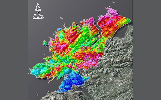
Geological Survey Ireland has released three new Tellus County Maps of County Donegal showcasing the county from a completely new perspective.
Since 2011, the Tellus program of Geological Survey Ireland — a division of Ireland's governmental Department of the Environment, Climate, and Communications — has been collecting geophysical data via onboard instruments on low-flying aircraft. The data, showing the magnetic, electromagnetic, and radiometric properties of the land, has now been compiled into a series of county maps with explanations on the information shown and key facts on the findings.
Every month, Tellus County Maps releases new maps, free of charge, that are useful for exploring deep geological features, while electromagnetic maps are good at showing the boundaries between different soils and rocks. Their radiometric maps also provide an excellent view of the extent of peatland.
Speaking after the release of the latest three Donegal maps, Koen Verbruggen, Director of Geological Survey Ireland, said: "Geologists and geophysicists have a different way of looking at things, both in terms of time and space. They use color to represent different properties of rock or millions of years in time."


Electromagnetic map of Donegal.
"People may remember the aircraft flying low above their homes and might have wondered was there anything unusual found in their county. These maps are a chance to show the results in a form that’s accessible to all and to show people a different way to look at County Donegal."
Donegal’s granite mountains and hills appear with high resistivity in the electromagnetic map. The magnetics map reveals faults running southwest to northeast, along with dykes running southeast to northwest. Finally, the radiometric map highlights the Barnesmore granite to the east of Letterkenny, appearing white on the map.

A radiometric map of County Donegal.
Airborne geophysics is a cost-effective means of detecting the physical properties of soil, rock, and water beneath the ground. The data can be used for various purposes, for example, geological mapping, mineral exploration, radon risk mapping, and geothermal energy exploration through the understanding of the subsurface. The Tellus program started in Northern Ireland, and it is planned that surveys of the island of Ireland will be completed by 2026.
The Tellus maps of County Donegal are available on the Geological Survey Ireland website.


Comments