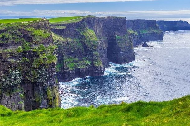
In the 1960s, the land around the Cliffs of Moher was nearly sold to a German businessman. Fifty years ago, the Co Clare landmark was a tourist attraction just as it is today. But back then, there was no visitor center, restaurant, shops, or even a parking lot. Tourists would park on the road, reach the cliffs by a narrow pedestrian walkway. and admire the view for free.
The fields around the cliffs were farmland for cattle and belonged to two branches of the Considine family of the nearby village of Liscannor.
Cousins Danny and Kathleen Considine owned 65 acres at Lislorkan North, as the townland around the cliffs is called. The property included fields ending at the cliff front and the land that O’Brien’s Tower stands on.
Writing for the Irish Times, Rosita Boland, whose father Joe Boland was Clare’s county manager at the time, tells the story of how in 1964 her father received a phone call from Brendan O’Regan, the chairman of Bord Fáilte and of the company that became Shannon Development. O’Regan told him that Germans were looking to purchase a substantial portion of land at the Cliffs of Moher.
Boland, fearing the land would fall into overseas ownership and not knowing how the land would be developed, began taking action to move it into council ownership.
On August 22, 1964, the local newspaper the Clare Champion reported the rumor of a potential foreign buyer for the land around the Cliffs.
The lead story carried the headline “Move to buy the famous Cliffs of Moher?” with a photograph of the cliffs.
The paper reported: “It was rumored during the week that a move was being made to buy the famous Clare landmark.”
The next week the Clare Champion reported: “German offer to buy Cliffs of Moher confirmed” ran the headline.
“Rumours that a German firm is interested in sixty-five acres of land with about a half-mile-long frontage on the Cliffs of Moher were confirmed when our representative visited a joint owner of the land, Miss Kathleen Considine.”
No sale had been made, but Kathleen told the reporter that her solicitor was in touch with solicitors in Dublin who were acting for the Germans.
The German firm looking to buy the land was named as “Eberhard Kemper, Essen Bradeney, Bruckerholts.”
Company representatives had first visited the cliffs in June, and when they heard about the Considines, told Kathleen of their interest. They did not reveal why they wanted the land.
“She added that she would sell the land if the price was right and if she could retain grazing rights as the Germans had stated she could,” reported the Clare Champion.

Love Irish history? Share your favorite stories with other history buffs in the IrishCentral History Facebook group.
The newspaper also visited Kathleen’s cousin Danny, who was not home at the time. His wife Kathy told the reporter that they “were of the same opinion” as Kathleen Considine about selling the land.
Danny died in 2007, aged 79, and his cousin Kathleen is also now dead. Danny’s widow Kathy, now 85, told the Irish Times that she does not know the amount that was offered to buy her husband’s land.
According to the Irish Times, the cousin’s combined 65 acres were divided in such a way that any potential buyer would need to purchase both plots, so both Danny and Kathleen would need to agree to sell if the buyer wanted full access to the cliffs.
Despite the long name, “Eberhard Kemper, Essen Bradeney, Bruckerholts.” was not three people but one factory owner, Eberhard Kemper. The other names were place names, possibly Kemper’s address at the time.
Before inquiring about the land at the Cliffs of Moher, Kempler had opened a textile factory in Drogheda, Co Louth. It seems unlikely he wanted to build a factory at the cliffs. The Irish Times speculates that he might have been interested in building a hotel on the land.
However, the land was never sold to Eberhard Kemper. Because Danny didn’t want to sell his portion of the land, Kathleen couldn’t sell as Kemper wanted the entire plot.
“Danny was a very devoted farmer,” Kathy Considine says of her husband. “Land was everything to him. It was land that was important to him, not money. He did not want to sell that land.”
This article was originally published in Ireland of the Welcomes magazine. Subscribe now!
After hearing about the potential German buyer, Clare’s county manager Joe Boland, who believed the land should be moved into public ownership to protect it against future private development, moved to act.
Clare County Council began negotiations to buy a small portion of Danny Considine’s land, The council wished to buy the land fronting the cliffs and the field known as the Tower Field, with the ruined O’Brien’s Tower on it.
Rosita Boland writes in The Irish Times: ”My father knew that this was the vital piece of land to bring into public ownership. Notwithstanding the public right of way to the cliffs, land without access to the Cliffs of Moher view would be of no interest to any future private developer.”
The Clare County Council purchased two acres and 25 perches (slightly less than a sixth of an acre) of Danny’s land for £1,000.
On March 16, 1968, the Clare Champion reported: “O’Brien’s Tower, Cliffs of Moher, the surrounding area of which Clare Co Council proposes to expend £6,700 on for the development of tourism.
“The Council proposes to expend the money on the purchase of the main section of the Cliffs of Moher, including the tower, and also the provision of additional parking for cars and buses. It is also intended to provide a viewing space on the roof of the tower and also a souvenir shop near the cliffs . . . The proposal to preserve the Cliffs of Moher as an amenity area for the benefit of the general public has been welcomed by many North Clare interests.”
Since that purchase, the Clare County Council has purchased more parcels from the Considines, who still own land at Lislorkan North. However, even now the council only owns 34.6 acres, a little over half of what Kemper wanted to purchase in 1964.
* Originally published in 2016, updated in April 2023.


Comments