Founded in 1945 to promote peace through education and cultural cooperation, UNESCO has grown into a global force for heritage, knowledge, and sustainability. Ireland, rich in history and tradition, is home to several UNESCO World Heritage Sites, treasures, and practices that showcase its unique place in the world.
In November 1945, the United Nations Educational, Scientific, and Cultural Organization (UNESCO) was founded in the aftermath of the Second World War. Best known for its work in designating and protecting World Heritage Sites - of which there are three on the island of Ireland - the organization was initially conceived to promote peace through international cooperation in education.
Today, UNESCO builds on that mission in tackling some of the most pressing global policy challenges from a cultural and scientific perspective.
UNESCO's objectives include attaining quality education and lifelong learning for all, mobilizing scientific knowledge and policy for sustainable development, addressing emerging social and ethical challenges, fostering cultural diversity, intercultural dialogue, and a culture of peace, and building inclusive knowledge societies through information and communication technologies.
UNESCO World Heritage Sites on the island of Ireland
Brú na Bóinne / The Boyne Valley (1993)
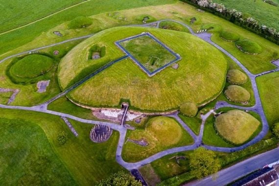
Knowth in the Boyne Valley.
Brú na Bóinne, which means the ‘palace’ or the ‘mansion’ of the Boyne, refers to the area within the bend of the River Boyne which contains one of the world’s most important prehistoric landscapes.
The archaeological landscape within Brú na Bóinne is dominated by the three well-known large passage tombs, Knowth, Newgrange, and Dowth, built some 5,000 years ago in the Neolithic or Late Stone Age. An additional 90 monuments have been recorded in the area, giving rise to one of the most significant archaeological complexes in terms of scale and density of monuments and the material evidence that accompanies them. The Brú na Bóinne tombs, in particular Knowth, contain the largest assemblage of megalithic art in Western Europe.
Sceilg Mhicíl (1996)
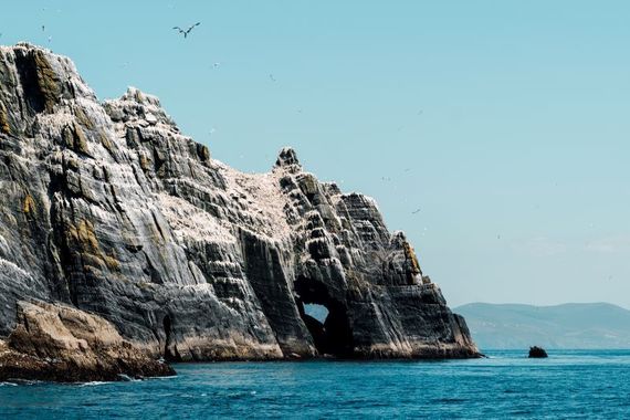
Sceilg Mhichíl, also known as Skellig Michael.
Sceilg Mhichíl, also known as Skellig Michael, was inscribed on the World Heritage List in 1996. The island of Sceilg Mhichíl lies at the extreme north-western edge of Europe, rising from the Atlantic Ocean almost 12 km west of the lveragh Peninsula in Co Kerry. It is the most spectacularly situated of all Early Medieval island monastic sites, particularly the isolated hermitage perched on narrow, human-made terraces just below the South Peak.
Giant’s Causeway and the Causeway Coast (1986)
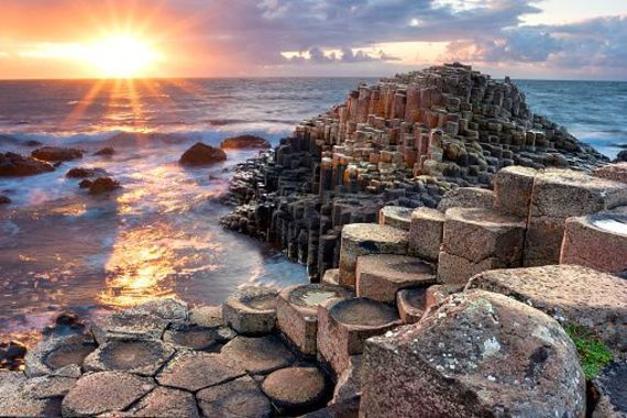
Giant’s Causeway and the Causeway Coast (1986).
The Giant's Causeway lies at the foot of the basalt cliffs along the sea coast on the edge of the Antrim plateau in Northern Ireland. It is made up of some 40,000 massive black basalt columns sticking out of the sea. The dramatic sight has inspired legends of giants striding over the sea to Scotland. Geological studies of these formations over the last 300 years have contributed significantly to the development of the earth sciences, and show that this striking landscape was caused by volcanic activity during the Tertiary, some 50–60 million years ago.
UNESCO Memory of the World Register
Book of Kells (2011)
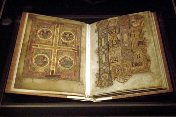
Book of Kells (inscribed in 2011).
The Book of Kells is widely regarded as Ireland's greatest historical treasure and is one of the most spectacular examples of medieval Christian art in the world. Its fame rests principally on the impact of its lavish decoration, the extent and artistry of which are incomparable.
The decoration ranges in complexity from full folio compositions based around initials or portraits to small details used to augment and emphasize text. Each page contains decoration. The Book of Kells attracts around 500,000 visitors to Trinity College Dublin every year, and functions for many, both in Ireland and further afield, as a cultural symbol of Ireland.
The Irish Folklore Commission Collection 1935-1970 (2017)
The Irish Folklore Commission Collection was assembled between 1935 and 1970 and forms the core archival material held in the National Folklore Collection, UCD. The collection comprises varied documentary formats, including audio, visual, manuscript, and rare printed materials, spanning all aspects of human endeavor and traditional knowledge, from material culture to oral literature, language, and artistic expression.
UNESCO Geoparks
Cuilcagh Lakelands UNESCO Global Geopark (formerly Marble Arch Cave)
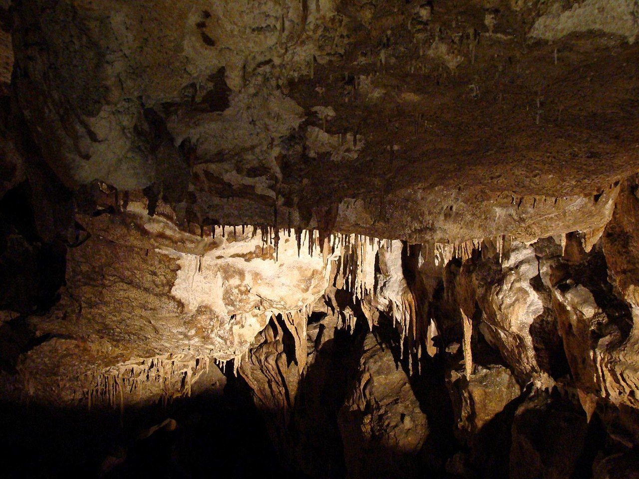
The Marble Arch Caves Global Geopark (cross-border counties Fermanagh and Cavan).
The Marble Arch Caves UNESCO Global Geopark is the World’s first UNESCO Global Geopark crossing an international border. It lies in the northwest corner of the island of Ireland, much of it is in Co Fermanagh in Northern Ireland, which is part of the United Kingdom, and a sizeable remainder is in Co Cavan in the Republic of Ireland.
The region displays a classic, glaciated landscape, comprising extensive uplands that successive ice sheets have smoothed. The uplands are intersected by broad U-shaped valleys that sweep down to the surrounding lowlands, where numerous lakes have formed in glacial hollows, and swarms of drumlins form many egg-shaped, rounded hills. The uplands contain extensive areas of forest, blanket bog, and karst, where the underlying limestone has been carved by abundant rainfall to form significant cave systems, including the world-famous Marble Arch Caves.
The caves are widely regarded as a world-class natural attraction containing marvelous stream passages formed by three rivers that sink underground on the slopes of Cuilcagh Mountain.
Copper Coast Global Geopark
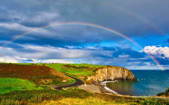
Copper Coast Global Geopark.
The Waterford Copper Coast is now a UNESCO Global Geopark, one of three in Ireland. It extends along the Co Waterford coastline for 25 km and is named after the 19th-century copper mines that lie at the heart of this spectacular stretch of cliffs.
Copper Coast UNESCO Global Geopark and Visitor Centre is located on the southeast coast of Ireland, between Tramore and Dungarvan in Co Waterford. It extends between Fenor in the east to Stradbally in the west and up to Dunhill in the north.
Burren and Cliffs of Moher Global Geopark
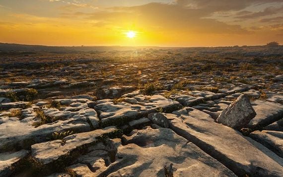
Burren and Cliffs of Moher Global Geopark
The Burren & Cliffs of Moher UNESCO Global Geopark, which covers an area of 530 km2, is bounded by Atlantic coastal cliffs (10-200 m high) to the west, the Gort lowlands to the East, and low, hilly terrain to the south. Much of the land is at an elevation of 100 m-200 m above sea level; the highest point is Slieve Elva at 344 m. The limestone area, which comprises most of the UNESCO Global Geopark, has few rivers, and only one (the Caher River) flows its entire length overground.
The geological landscape is one of glacially smoothed Carboniferous (300 million years ago) fossil-rich limestone hills, dramatic sea cliffs, seasonal lakes, and vast networks of subterranean caves. This physical landscape hosts rare natural habitats and unique floral assemblages not found anywhere else on Earth, as well as abundant legacies of human settlement dating back over 6,000 years.
UNESCO Biosphere Reserves
Dublin Bay (1981)
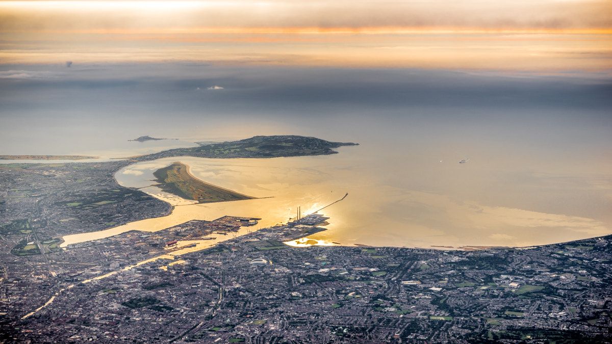
Dublin Bay (1981).
The Dublin Bay Biosphere Reserve (formerly North Bull Island) comprises Dublin Bay, North Bull Island, and adjacent land, including parts of Dublin, the capital city of Ireland. It is one of the finest sand dune systems in Ireland and is internationally important for its conservation value. There are high-quality examples of several rare and threatened coastal habitats present on the island.
Kerry (1982)
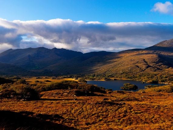
Kerry (1982)
The Kerry Biosphere Reserve (formerly Killarney) comprises the mountains and woodlands surrounding Lough Leane Lake and adjacent smaller lakes, moorlands, parks, and gardens.
Human history has also left its mark in the biosphere reserve, e.g., with the well-preserved remains of Inisfallen Abbey on an island in Lough Leane, Muckross Abbey, or the Muckross House, which serves as a visitor center today. This Killarney National Park Education Centre fulfills an essential educational role within the national park and biosphere reserve, which is one of the best-known tourist destinations in Ireland.
UNESCO's Irish Intangible Cultural Heritage inscriptions
Uilleann piping (2017)
Uilleann piping is a musical practice that uses a particular type of bagpipe (known as the ‘uilleann’, ‘Irish’ or ‘union’ pipes) to play Irish music. It is a highly developed instrument with strong roots in a tradition dating back many generations.
Hurling (2018)
Hurling, or Camogie (a form of Hurling played by women), is a field game played by two teams that dates back 2,000 years and features strongly in Irish mythology, most notably in the epic saga of Cú Chulainn. It is played throughout the island of Ireland, particularly in more fertile agricultural areas, and overseas.
Irish harping (2019)

Harping at the Hill of Uisneach in Co Westmeath. (Ireland's Content Pool)
Irish harping is at the heart of the identity of the people of the island of Ireland. The harp is Ireland’s national symbol and has been played for more than 1,000 years; its bell-like sounds and music captivate all those who hear it and are celebrated in Irish mythology, folklore, and literature.
Nowadays, instead of a harp hewn from a single piece of willow, strung with wire strings and played with the nails, most contemporary harps are made with various types of hardwood, strung with gut or nylon, and played with the fingertips.
Falconry, a living human heritage (2021)

Falconry in Navan, Co Meath. (Ireland's Content Pool)
Falconry is the traditional art and practice of training and flying falcons (and sometimes eagles, hawks, buzzards, and other birds of prey). It has been practised for over 4000 years.
Art of dry stone construction, knowledge and techniques (2024)

Dry Stone Wall Building in Kileel, County Down. (Ireland's Content Pool)
The art of dry stone construction is the practice of building with stone without using binding materials. Practised in various countries across Europe, it requires an innate understanding of geometry and physics, as well as the ability to handle the raw materials used.
* Originally published in 2020, updated in Oct 2025.
Comments